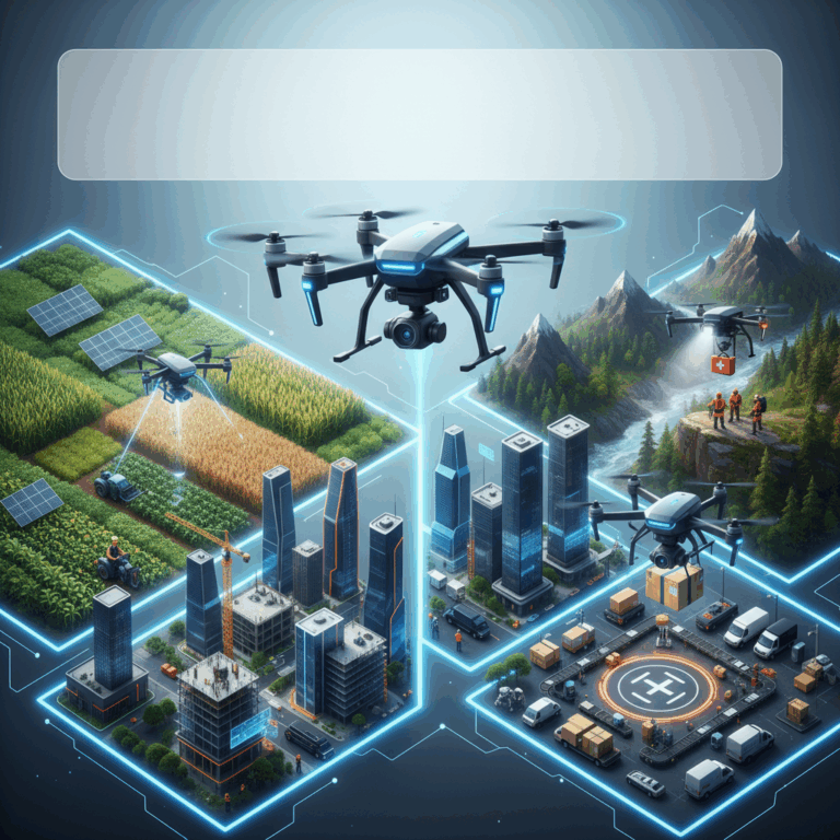
Drone Applications in Agriculture and Construction
Drones have revolutionized agriculture by enabling precision farming practices that boost crop yields and reduce environmental impact. Their sensor technology allows farmers to monitor crops closely and make informed decisions efficiently.
In the construction sector, drones provide real-time aerial data that enhances site surveying and improves safety. They help reduce manual labor and accelerate project planning by capturing detailed images and 3D models of construction sites.
Both industries benefit greatly from drones’ ability to gather accurate data quickly, minimizing risks and costs while optimizing operational workflows.
Precision Farming with Sensor Technology
Drones equipped with high-resolution and multispectral sensors help detect crop health issues early by monitoring soil and plant conditions. This technology enables targeted application of fertilizers and pesticides, reducing waste and environmental harm.
Farmers gain valuable insights into irrigation needs and nutrient deficiencies, enhancing yield management and sustainability. The data collected supports smarter decision-making and timely interventions to prevent crop losses.
These innovations allow agriculture to become more sustainable and efficient by providing precise, actionable information that was previously difficult or costly to obtain.
Construction Site Surveys and Safety Enhancements
Drones streamline construction site surveys by quickly capturing aerial views and 3D models, facilitating more accurate planning and progress tracking. This reduces the need for manual inspections and speeds up decision-making.
The use of drones also increases worker safety by limiting exposure to hazardous environments. Real-time monitoring allows for early identification of potential risks, helping to prevent accidents on-site.
Overall, drones improve efficiency and safety in construction, making project management more effective and cost-efficient through advanced aerial data collection.
Manufacturing, Industrial Inspection, and Emergency Uses
Drones play a transformative role in manufacturing by enabling AI-driven inventory management and quality control. They automate data collection and tracking, enhancing accuracy and reducing labor costs.
In industrial inspection, drones offer safer alternatives for examining infrastructure such as power lines and pipelines. This reduces human risk and minimizes downtime while maintaining operational reliability.
Emergency response teams leverage drones for search-and-rescue missions, utilizing their rapid deployment and aerial capabilities to access difficult areas and deliver critical supplies swiftly.
AI-Driven Inventory and Quality Control
In manufacturing and warehousing, AI-integrated drones streamline inventory management by automating stock counting and location tracking. This allows more frequent and precise audits without interrupting operations.
These drones also improve quality control by capturing detailed images and data of products, helping detect defects early. Automation reduces manual labor, speeding up inspection processes and enhancing consistency.
Overall, AI-powered drones contribute to increased efficiency and reduced operational costs while maintaining high standards of product quality and inventory accuracy.
Infrastructure Inspection for Risk Reduction
Drones inspect critical infrastructure like power lines, wind turbines, and pipelines more safely and efficiently than traditional methods. They access hard-to-reach areas without risking personnel safety.
By collecting high-resolution images and sensor data, drones detect structural issues early, preventing failures and costly downtime. This proactive approach significantly reduces maintenance risks and operational interruptions.
The use of drones also accelerates inspection schedules, allowing more frequent assessments that support better asset management and regulatory compliance.
Drone Role in Search-and-Rescue Missions
Drones assist emergency responders by quickly surveying disaster zones and locating missing persons with thermal imaging and real-time video. Their agility ensures coverage of large or inaccessible areas effectively.
They can deliver supplies such as medical kits and communication devices to trapped or isolated individuals, ensuring timely aid before rescuers arrive. This capability improves outcomes in critical situations.
By reducing search times and enhancing situational awareness, drones increase the overall effectiveness of rescue operations and help save lives during emergencies.
Environmental, Real Estate, and Military Deployments
Drones provide invaluable support in environmental conservation by monitoring ecosystems and tracking wildlife with minimal disturbance. Their data assists in protecting biodiversity and managing natural resources efficiently.
In real estate, drones capture stunning aerial images and videos, offering unique property perspectives that enhance marketing efforts and attract potential buyers with immersive visuals.
Military applications of drones focus on intelligence gathering, reconnaissance, and precision targeting, utilizing advanced sensors and AI to improve mission success while reducing risks to personnel.
Conservation Monitoring and Wildlife Tracking
Drones enable researchers to monitor wildlife populations and habitats effectively without intrusive human presence. This reduces stress on animals and allows continuous data collection over large areas.
Equipped with thermal and multispectral sensors, drones detect movement patterns and health indicators in various species. These insights help in making informed conservation decisions and protecting endangered wildlife.
This technology enhances the ability to combat poaching, track migration routes, and study environmental changes with high accuracy and cost-efficiency.
Aerial Imagery for Real Estate Marketing
Real estate professionals use drones to create compelling aerial photography and video tours, showcasing properties from angles impossible to capture otherwise. This attracts more potential buyers effectively.
The ability to display large estates, neighborhood surroundings, and property features in detail helps buyers make faster and more informed decisions. Drone imaging adds significant value to listings.
High-quality visuals generated by drones also support virtual reality experiences, enabling remote clients to explore properties dynamically, enhancing the marketing reach globally.
Military Intelligence and Precision Targeting
Drones in military operations provide critical real-time intelligence and surveillance, allowing forces to gain situational awareness while minimizing personnel exposure to danger. They enhance battlefield decision-making significantly.
Advanced onboard AI systems process sensor data for target identification and tracking, increasing the precision of strikes and reducing collateral damage. This capability transforms modern warfare tactics.
UAV deployments support varied missions, from reconnaissance to direct engagement, demonstrating flexible and effective force multipliers that improve strategic outcomes.
Future Trends and Technological Advances in Drones
The future of drone technology promises remarkable enhancements driven by AI and autonomy. These advances enable drones to operate with minimal human intervention, performing complex tasks efficiently.
Innovations focus on improving flight duration, navigation systems, and decision-making capabilities. This results in broader applications and increased reliability, transforming how industries utilize drones.
As technological progress unfolds, drones will become indispensable tools, offering safer, more cost-effective solutions across diverse sectors worldwide.
AI and Autonomy Enhancing Drone Capabilities
AI integration empowers drones to analyze data in real-time, adjust flight paths, and complete missions independently. This autonomy reduces the need for constant manual control.
Enhanced perception systems allow drones to detect obstacles, adapt to changing environments, and coordinate with other drones for complex tasks, increasing operational safety and efficiency.
These advancements extend the use of drones beyond visual line-of-sight operations, enabling longer-range missions and more sophisticated applications.
Consequently, drones become smarter, safer, and better equipped to handle dynamic scenarios across industries such as agriculture, inspection, and emergency response.
Expanding Operational Scope and Cost Efficiency
Technological advances lower production and maintenance costs while enhancing drone durability and battery life, making drone adoption more feasible for businesses of all sizes.
The expanding capabilities allow drones to perform diverse functions—from detailed mapping and monitoring to cargo delivery—broadening their operational scope significantly.
Improved efficiency reduces the time and manpower required for tasks, resulting in substantial savings and higher productivity.
As drones become more accessible and versatile, industries will increasingly leverage them to optimize workflows and achieve better outcomes at lower costs.


